1.0 Introduction
Mountainous regions such as Colorado are notorious for being susceptible to flash floods and extreme precipitation events. These events can occur when moisture-rich lower tropospheric air flows into high terrain by either large-scale flow patterns and/or solenoidal circulations resulting from heating of elevated terrain. As this air flows into high terrain, it undergoes orographic ascent, cools to saturation, and often leads to convective instabilities. Extreme precipitation can then occur as a result of localized terrain-induced heavy precipitation in widespread storm systems, and/or from strong convective storms. Moreover, complex mountainous terrain includes deep canyon systems which can channel rainfall runoff producing deadly and damaging flash floods.
Current methodologies of probable maximum precipitation (PMP) (Hansen et al., 1988) and flood estimation have been shown to be incompatible with paleohydrographic results when applied to high mountainous terrain. Using stratographic and geomorphic evidence, Jarrett (1993) and Jarrett and Costa (1983) conclude that there is little evidence of extreme rainfall and floods above 7500 ft elevation. Above 7500 ft elevation, they argue that much of the heavy precipitation falls as snow which results in slow discharge rates, while below that elevation rainfall occurs resulting in heavier precipitation amounts such as associated with storms as the Big Thompson Flood (Maddox et al., 1977; Caracena et al., 1979) and the Fort Collins flood (Doesken and McKee, 1998; NOAA, 1997). We also argue that as moist air ascends along mountain slopes it condenses and forms precipitation on convective towers before it reaches high terrain. Thus, the moist air is intercepted by the convective towers before it reaches the highest elevations. These studies suggest that current PMP estimates may overestimate high elevation rainfall potential by a factor of two. This overestimate, if supported by further studies, has major economic consequences as it effects the design and construction of dams at elevations above 7500 ft.
Our plan is to apply a three-dimensional (3D) convective storm model to develop a new method of estimating extreme precipitation and to develop concepts of how extreme precipitation varies with altitude in Colorado. The model which we shall use is the Regional Atmospheric Modeling System (RAMS; Pielke et al., 1992) developed at Colorado State University under the direction of the Principal Investigator. RAMS has been applied to the simulation of convective storms and rainfall in many parts of the world (Cotton et al., 1995; Alexander and Cotton, 1998; Abbs and Ryan, 1994), the U.S. (Bernardet and Cotton, 1998; Bernardet et al.,1998; Grasso and Cotton, 1998; Finley and Cotton, 1998), and in particular in Colorado (Tripoli and Cotton, 1986; Tripoli and Cotton, 1989a,b; Nachamkin, 1998). RAMS has also been run as a prototype realtime forecast model over Colorado since 1991 (Cotton et al., 1994; Cotton et al., 1995; Gaudet and Cotton, 1998), so that it is safe to say that we have had more experience in meteorological modeling over Colorado than anyone.
While RAMS can be run in two-dimensions (2D) or 3D initialized with a single sounding, it is our experience that a 2D model is less consistent in precipitation simulation than a 3D model. The 2D model sometimes overestimates and sometimes underestimates rainfall (see Cotton and Anthes, 1989) owing to the sometimes compensating effects in 2D of underestimating low-level moisture convergence and underestimating cloud-level entrainment of dry air. Furthermore, storm motion is artificially constrained in 2D, often resulting in unrealistic motions. In reality, curvature of wind hodographs and complex storm outflows/inflows can result in quasi-stationary storms in 3D.
Likewise RAMS can be initialized either from a single "representative" sounding or from the objective analysis of large scale data and interactive nesting from the mesoscale to the storm scale. The former procedure involves two rather arbitrary steps. The first step involves the selection or construction of a "representative" sounding. In Colorado soundings are taken at only two sounding sites (Denver and Grand Junction) and twice a day. Thus a particular storm may form as much as six or more hours and several hundred kilometers from any actual atmospheric sounding. Much of the effort in performing single sounding simulations involves rather arbitrary "tweaking" of actual soundings. A second arbitrary step often used in the single-sounding approach is the introduction of artificial "hot bubbles" in order to initiate convection, since the homogeneous intialization lacks the usual environmental triggers (e.g., low-level convergence). Such hot bubbles can have a significant effect on the subsequent behavior of the simulated convection. Finally, because single-sounding runs typically do not include large-scale environmental forcing (e.g., low-level convergence, temperature, and moisture advection), the simulated convection, regardless of how it is initialized, often does not evolve realistically.
Our preferred procedure is to perform interactive nested grid simulations of the evolving large- scale or synoptic state of the atmosphere, the corresponding mesoscale circulations that are driven by flow over complex terrain and by surface heating over the regions, and the explicit formation and evolution of convective storms. The procedure is analogous to that used in our research case studies, and is an extension of those used daily in our realtime forecast model. In a sense this procedure simulates the evolution of the "representative" soundings and circulations at the location and time of convective storm formation. Moreover, the convective storms develop naturally in response to those mesoscale circulations and local surface heating without the need to introduce arbitrary hot bubbles or cold pools.
Using these baseline simulations of observed heavy precipitation events as our "control runs," we will develop a methodology of perturbing the large-scale meteorology and surface conditions about known or estimated uncertainties to produce an "ensemble" of simulations for each selected heavy precipitation event. From this ensemble of simulations we will objectively define extreme precipitation amounts that can occur in the region of each observed event over the range of possible environmental variations of that event.
2.0 Specific Aspects of the Proposed Method of Extreme Precipitation Estimation
The atmospheric model that we will use is the Regional Atmospheric Modeling System (RAMS) developed at Colorado State University (Pielke et al., 1992). RAMS contains interactive, telescopically nested grids that permit the model to better resolve atmospheric processes over particular regions of interest. RAMS can be initialized from data sets used to initialize operational forecast models or data sets available from NCAR or NCDC in which the soundings and surface data are objectively analyzed over the RAMS courser grids. The model can then run freely as a forecast model for periods of days during which the coarse grid lateral boundaries are nudged by either forecast model data or by objectively-analyzed large- scale data.
The procedures for assimilating large scale meteorological data are well worked out as we have been running RAMS in realtime over Colorado to produce precipitation forecasts since 1991 (Cotton et al., 1994; Cotton et al., 1995; Gaudet and Cotton, 1998).
RAMS also contains one of the most sophisticated sets of physics packages available in any atmospheric model, be it cloud or global scale. It has a very sophisticated, though computationally fast, precipitation physics module (Walko et al., 1995; Meyers et al., 1997; Feingold et al., 1997) and parameterization schemes for boundary layer clouds (Golaz, 1998), deep convective clouds (Rafkin, 1996), and mesoscale convective systems (Alexander and Cotton, 1998). It has a new two-stream radiation scheme that is fully interactive with the cloud physics modules (Olsson et al., 1998; Harrington, 1997; Harrington et al., 1998). Moreover, a land surface/atmosphere transfer scheme (LEAF- 2; Walko et al., 1998) has been added to RAMS. This module represents the energy balance of solar and longwave radiative fluxes at the surface with sensible and latent turbulent heat fluxes and ground heat conduction. The latent fluxes are evaluated separately for evaporation from the soil and from intercepted water on vegetation, and for transpiration through the stoma on plants. The water budget is similarly represented and includes a subgrid representation of runoff using a version of TOPMODEL (Band, 1993). LEAF-2 must be initialized with observed distributions of soil type and soil moisture profiles. Also in LEAF-2 vegetation phenologies are predefined according to geographic location and time of year. Except for the most recent cases, these data will not be available so that we will have to make estimates of their values. These uncertainties will be part of the ensemble simulations discussed below.
Up to 20 historical storm events, selected from the "recommended final list of storms" in McKee and Doesken (1997), will be used as control cases, as well as more recent events such as the 1997 Fort Collins flood. The 22 cases in the "final list" since 1957 will be the highest priority, since surface and upper-air datasets in the post- 1957 era have undergone consistent global dynamic reanalysis (Kalnay et al., 1996) by the National Center for Environmental Prediction (NCEP) and the National Center for Atmospheric Research (NCAR). These cases collectively affected all six of the Colorado hydroclimatic regions identified by McKee and Doesken (1997), with each region affected by one or more occurrence of at least two out of the three types of storm events (General, Local Convective, and General with Local Convective Storms embedded). An additional two events in the early/mid-1950's have upper-air data available, so that they may also be simulated. These cases, and variations of them as described below in the ensembles of simulations, should represent a comprehensive set of meteorological conditions that can produce extreme precipitation at higher elevations in Colorado. While the first twelve events in the "final list" occurred in the pre-sounding era and thus cannot be reliably initialized for simulation, their surface analyses will be compared to events in the sounding era. If any of these older analyses indicate favorable surface conditions (e.g., upslope component of surface geostrophic wind; surface dewpoints) that are more extreme than in more recent cases with similar surface patterns, then we will insure that such extreme conditions are encompassed in the ensemble simulations for the more recent cases.
|
The NCEP/NCAR reanalysis, at a 2.5o x 2.5o latitude/longitude grid-point spacing on 17 vertical levels, will provide the "first-guess" 3D atmospheric initialization for the control case simulations, as well as time-dependent lateral boundary conditions on the coarsest grid (Fig. 1a). Using the objective analysis module in RAMS, the "first-guess" fields will be "enhanced" with soundings and surface observations. This will add significant mesoscale detail evident in the Denver, Grand Junction, and surrounding soundings, but which may have been overly smoothed in the NCEP/NCAR analyses. This "enhancement" will be especially important in adding surface and low-level mesoscale detail based on denser surface observations. Soil moisture and vegetation fields will be initialized based on available datasets (e.g., Palmer Drought Severity Index; state and USDA agricultural surveys) and/or on techniques utilizing observed antecedent precipitation. For events that occurred outside Colorado (e.g., the 1972 Rapid City flood), the objectively analyzed fields can be translated such that the observed storm location is re-centered over the Colorado region of interest, with appropriate low-level adjustments made for differing topography.
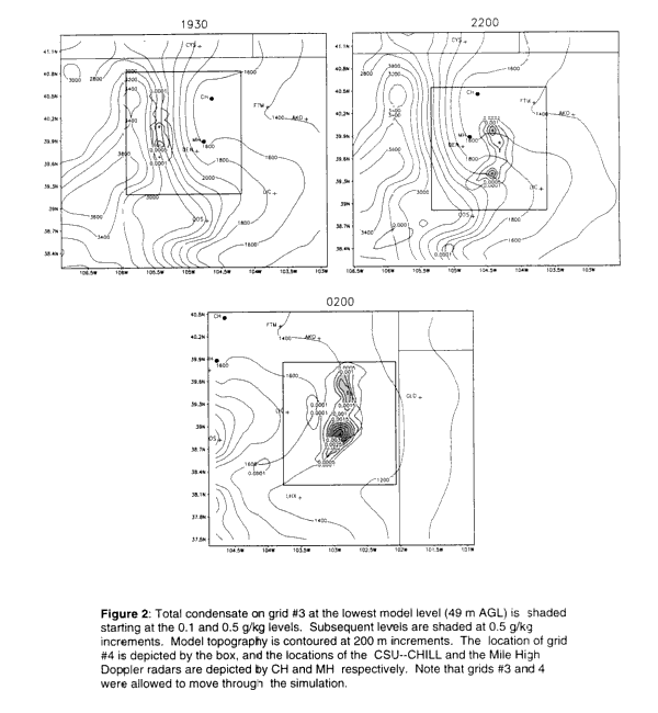 |
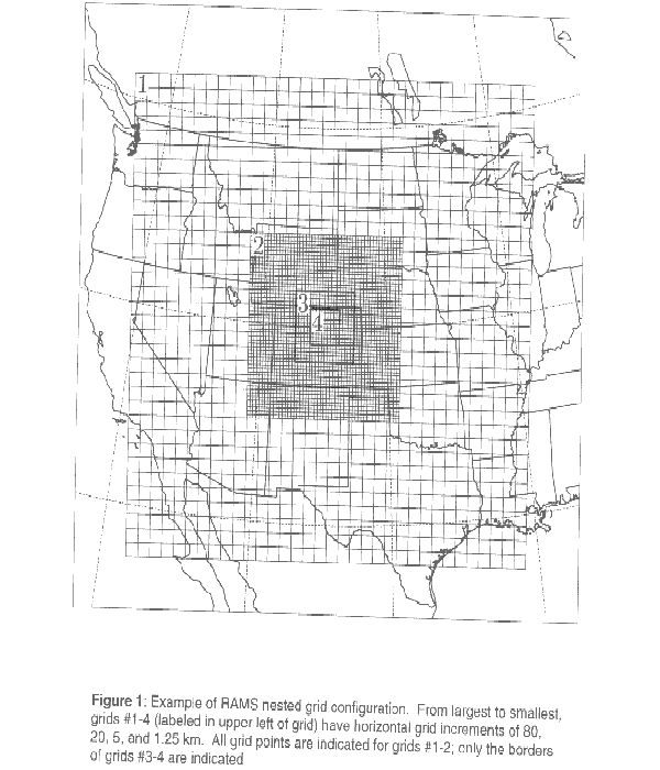
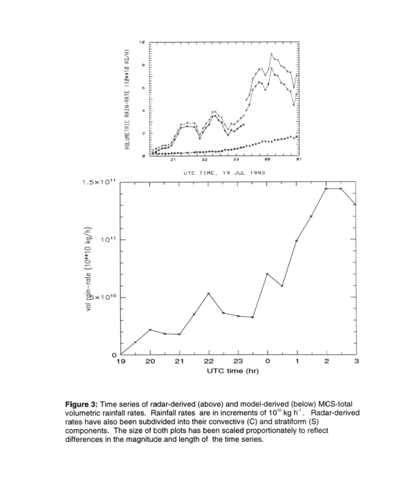
These datasets will be assimilated into the interactively-nested RAMS grid configuration. Figure 1 shows such a nested grid configuration that might be used for the Big Thompson Flood. Grid #1 covers most of the western and central U.S. at 80-km grid spacing, with successively finer Grids #2-4 having grid spacings of 20, 5, and 1.25- km, respectively. The finest grid, Grid #4, covers a roughly 200-km x 200-km domain centered about the flood region, and is a cloud-resolving grid on which convection is explicitly resolved. Figure 2 shows an example of an explicitly simulated storm in northeastern Colorado that formed on 19 July 1993. RAMS was set up much like we propose to do for this study with a regional parent grid having 80km grid spacing and then nested to a cloud-resolving grid with 1.67 km grid spacing. Nachamkin (1998) found that the simulated storm closely resembled the observed case in terms of the morphological evolution of the individual convective cells, and in the evolution of radar-estimated vs. simulated volumetric precipitation rate rainfall (see Figure 3).
 |
The first simulation for each case, using the initialization procedures described above, will represent the "control" simulation for that event. We then propose to perform a set of about ten additional simulations for each case, where the control initialization is perturbed using a methodology similar to that used in ensemble forecasting. The ensemble simulations will include perturbations that represent even more extreme conditions (e.g., precipitable water) than observed in the extreme precipitation event, and collectively will reveal the range of plausible outcomes over the fine-grid region for that type of synoptic setting.
 |
Ensemble forecasting has mainly been applied to atmospheric models in which only meteorological fields are perturbed. The methods consist of introducing perturbations using Monte Carlo procedures (Mureau et al.,1993), lagged average forecasting (Toth and Kalnay, 1993), use of singular vectors (Mureau et al., 1993), and breeding of growing modes (Toth et al., 1997). We plan to perturb the atmospheric field using some form of dynamic conditioned errors such as represented by the last three techniques. Because we are examining extreme events at a specific location, we will examine the effects of positioning errors in the positioning of the synoptic pattern by moving the synoptic patterns in a ground-relative sense as a component of the ensembles. In addition, we propose to perturb the surface properties such as soil moisture and vegetation parameters using a Monte Carlo type procedure. As far as we know, we will be breaking new ground by perturbing ground surface parameters in applying ensemble forecasting procedures.
By making credible variations on the initial state of such actual heavy precipitation events, we will, in effect, be simulating rare cases representative of very long return periods of various environmental factors that support extreme precipitation events. The ensemble of simulations will produce a distribution of precipitation amounts for the period of simulation. Out of this distribution of precipitation amounts the maximum value will represent the extreme precipitation for that location and for a region surrounding the actual flood event. One should expect that the imposed perturbations will not only alter the magnitude of maximum precipitation but also the locations of the maxima. We expect that one of the ensemble members should provide the best verification of simulated precipitation for the available observations. This best verified case will be used in the quality control analysis discussed below.
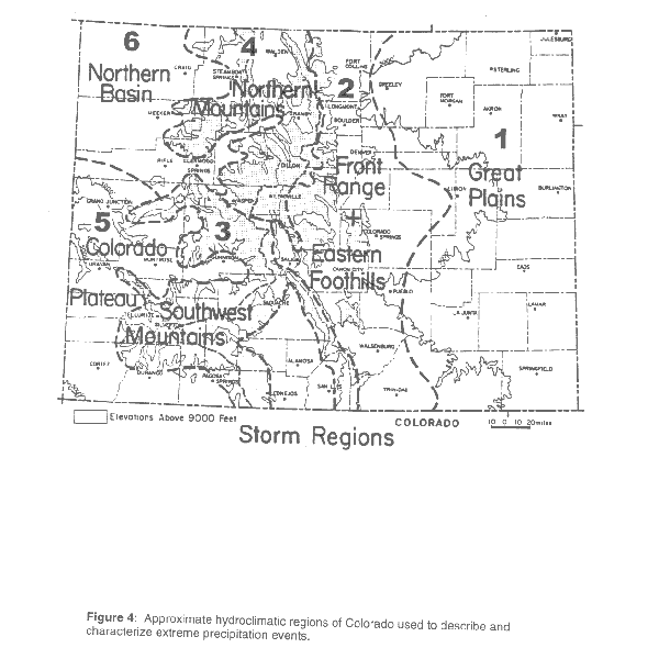
After we have performed this procedure for as many of the 20 selected cases as possible, we should be able to identify a parameter space for perturbing initial input data that is specific to identifying extreme precipitation amounts for any particular location in Colorado. Thus for any of the hydrological regions of Colorado shown in Figure 4(McKee and Doesken,1997) we should be able to identify the ensemble mean initial meteorological and surface characteristics that yield extreme precipitation for that sub-region. Then, based on our experience with the ensemble simulations for the 20 selected cases, we perturb those initial conditions over the parameter-space that is representative of the extreme precipitation simulations. The largest precipitation amounts for the ensemble of simulations will represent the extreme precipitation amount for that particular location. The model should also be able to identify those cases where the precipitation is large but it is in the form of graupel or hail with slow rates of runoff.
The final deliverable will be a Graphical User Interface(GUI) to the RAMS source code. The user will identify the coordinates or click on a map the location in Colorado where extreme precipitation estimates are desired. The GUI will then select one or more historical extreme precipitation synoptic patterns for the region of interest(ie. western Colorado, central Colorado, etc.). The GUI will then move the selected synoptic patterns to conform with the selected locations and then perform the ensemble of simulations using the perturbing methodology identified in the historical case simulations. The output will include such things as the extreme precipitation estimate for that specific location and the variance relative to that maxima, mappings of extreme precipitation, and gridded data sets of the extreme and highest precipitation ensembles for use in driving runoff models.
3.0 Plan for Quality Assurance
It is entirely possible that we will find that the model exhibits a bias in simulated precipitation(eg. that it consistently over-predicts or under-predicts observed precipitation amounts or in the partitioning of precipitation between rain and graupel/hail). Such biases are found in operational forecast models. However, the operational models do not come close to the grid spacings that we propose to use in this study. We may nonetheless find a bias and must account for it quantitatively.
Our plan for quality assurance will begin by performing detailed evaluation of the ensemble members for each selected extreme precipitation event. The most realistic or representative ensemble member for a given event will be selected based on comparisons between the simulation and observations. This evaluation will include the model's performance in simulating observed synoptic and mesoscale meteorological features on the coarser grids, the overall distribution of precipitation on all grids, and a number of simulated storm characteristics on the cloud-resolving grid. The evaluation on the cloud-resolving grid will consider modeled vs. observed precipitation distribution and amounts, the type of storm event (General, Local Convective, or General/Local Convective), storm structure for convective events (single-cell vs. multicell), storm duration and movement, radar reflectivity and echo tops (when available), precipitation type (rain or graupel/hail) vs. elevation, and surface outflow characteristics.
Note that the most representative ensemble member will not be based solely on modeled vs. observed precipitation amount for the storm of interest, as we may find that the model exhibits a systematic bias in simulated precipitation amount. That is, the most representative ensemble member for each event as evaluated above will replicate the overall observed meteorology including storm-scale characteristics most realistically, but may be found to consistently over-predict or under-predict observed precipitation.
Our uncertainty concerning simulated precipitation amounts at the ground in RAMS stems from the fact that absolute precipitation verification, with the exception of wintertime precipitation over Colorado (Gaudet and Cotton, 1998), has never been an objective in our prior research. While the highly sophisticated microphysics parameterization has been developed and tuned based on detailed bin microphysical modeling and in-cloud microphysical measurements in the literature, the emphasis in our case study simulations utilizing the microphysics parameterization has always been on other detailed aspects of storm evolution (e.g., tornado mechanisms, severe wind, MCS growth and diagnostic studies) rather than precipitation amount. However, the excellent agreement between simulated and observed storm structure and evolution in these case studies gives us confidence that precipitation is realistically simulated. In short, we believe that precipitation patterns and evolution can be simulated very realistically, with the vertical mass flux in the storm updrafts realistically constrained by the simulated mesoscale evolution, despite any biases that may arise from subgrid-scale processes or microphysical deficiencies affecting precipitation efficiencies.
These possible biases will be evaluated by statistical analysis of simulated vs. observed precipitation for the extreme storm events, using the most representative ensemble member for each event. The analysis will optimally include the spatial and temporal distribution of observed precipitation, including rain vs. graupel/hail, where available; time-integrated area-depth-duration analyses if available; and total storm precipitation as estimated in the case files identified by McKee and Doesken (1997). As a first correction, a linear relationship between simulated vs. observed precipitation amounts (or rates) will be identified to correct for any bias. If the correction is found to be adequate for the representative ensemble member for most cases, then that same correction can be applied to all ensemble members in the evaluation of PMP.
If a highly non-linear bias is found, we will investigate the feasibility of adapting an artificial neural network (ANN) system, developed for precipitation estimation by Hsu et al. (1997), to simulated precipitation correction. This system has several important features that are suitable for dealing with high-dimensional, complicated non-linear function mapping of multiple input variables that are correlated with rainfall intensity and distribution. The ANN would be "trained" with the observed events using a number of input variables, including simulated storm-total precipitation, topographic information, and observed and/or modeled meteorology such as cloud base height, subcloud thermodynamic profiles, and tropospheric shear; the predicted output variable is corrected storm-total simulated precipitation, evaluated against the observed values. Similar statistical evaluation of liquid vs. ice precipitation biases will made and corrections developed. Through such statistical evaluation and correction of the model's simulated precipitation for the observed events, application of the correction to simulated precipitation in other ensemble members or to independent cases focusing on specific watersheds can be reliably made for PMP estimation.
4.0 Project Milestones
The following are the project milestones:
A timeline of these tasks is as follows:

5.0 Bibliography
Abbs, D.J., and B.F. Ryan, 1994: Numerical modelling of extreme precipitation events. UWRAA Research Project WR-22, Division of Atmospheric Research, CSIRO, Mordialloc, Vic, 3195, Australia, 39 pp.
Alexander, G. David, and William R. Cotton, 1998: The use of cloud-resolving simulations of mesoscale convective systems to build a convective parameterization scheme. J. Atmos. Sci., 55, 408-419.
Band, L.E., 1993: Effect of land surface representation on forest water and carbon budgets. J. of Hydrology, 150, 749-772.
Bernardet, L.R., W.R. Cotton, 1998: Multi-scale evolution of a derecho-producing MCS. Mon. Wea. Rev., accepted for Aug.
Bernardet, L.R., J.E. Nachamkin, C.A. Finley, L.D. Grasso, and W.R. Cotton, 1998: Forecasting convective events using a high-resolution mesoscale model. Submitted to J. Geophys. Res.
Caracena, F., R.A. Maddox, L.R. Hoxit, and C.F. Chappell, 1979: Mesoanalysis of the Big Thompson storm. Mon. Wea. Rev., 107, 1-17.
Cotton, W.R. and R.A. Anthes, 1989: Storm and Cloud Dynamics. Academic Press, Inc., San Diego. International Geophysics Series, Vol. 44., 883 pp.
Cotton, W.R., G. Thompson, and P.W. Mielke, Jr., 1994: Real-time mesoscale prediction on workstations. Bull. Amer. Met. Soc., 75, 349-362.
Cotton, William R., John F. Weaver, and Brian A. Beitler, 1995: An unusual summertime downslope wind event in Fort Collins, Colorado on 3 July 1993. J. Weather Forecasting, 10, 786-797.
Doesken, Nolan J., and Thomas B. McKee, 1998: An analysis of rainfall for the July 28, 1997 flood in Fort Collins, Colorado. Climatology Report 98-1, Colorado Climate Center, Dept. of Atmospheric Science, Colorado State University, Fort Collins, CO 80523-1371, 55 pp.
Feingold, G., R. Boers, B. Stevens, W.R. Cotton, 1997: A modeling study of the effect of drizzle on cloud optical depth and susceptibility. J. Geo. Res., 102, 13,527-13,534.
Finley, C.A., W.R. Cotton, R.A. Pielke, 1998: Numerical simulation of tornadogenesis in a high-precipitation supercell: Part I: Storm Evolution and Transition into a bow echo. Submitted to J. Atmos. Sci.
Gaudet, B., and W.R. Cotton, 1998: Statistical characteristics of a real-time precipitation forecasting model. Accepted in Wea. Forecasting.
Golaz, Jean-Christophe, 1998: Development of a single-column model for simulating precipitating stratocumulus clouds. M.S. Thesis, Atmospheric Science Paper #638, Colorado State University, Dept. of Atmospheric Science, Fort Collins, CO 80523.
Grasso, L.D., and W.R. Cotton, 1998b: The simulation of two tornadic thunderstorms initiated by dry line dynamics--Part II: Simulated tornadoes. Submitted to J. Atmos. Sci.
Hansen, E.M., D.D. Fenn, L.C. Schreiner, R.W. Stodt, and J.F. Miller, 1988: Probable Maximum Precipitation Estimates - United States Between the Continental Divide and the 103rd Meridian. Hydrometeorological Report No. 55A, U.S. Department of Commerce, Silver Spring, MD, June, 242 pp.
Harrington, Jerry Y., 1997: The effects of radiative and microphysical processes on simulated warm and transition season Arctic stratus. Ph.D. dissertation, Atmospheric Science Paper No. 637, Colorado State University, Dept. of Atmosp heric Science, Fort Collins, CO 80523, 289 pp.
Harrington, J.Y., T. Reisin, W.R. Cotton, S.M. Kreidenweis, 1998: Cloud resolving simulations of Arctic stratus. Part II: Transition-season clouds. Submitted to Atmos. Res.
Hsu, K., X. Gao, S. Sorooshian, and H.V. Gupta, 1997: Precipitation estimation from remotely sensed information using Artificial Neural Networks. J. Appl. Meteor., 36, 1176--1190
.Jarrett, R.D., 1983: Flood elevation limits in the Rocky Mountains. In Kuo, C.Y., ed., Engineering hydrology -- Proceedings of the symposium sponsored by the Hydraulics Division of the American Society of Civil Engineers, San Francisco, CA, July 25-3 0, 1983, New York, American Society of Civil engineers, p. 180-185.
Jarrett, R.D., and J.E. Costa, 1983: Multidisciplinary approach to the flood hydrology of foothill streams in Colorado. International Symposium on Hydrometeology (A.I. Johnson and R.A. Clark, eds.), American Water Resources Association, June 1 3-17, 1982, Denver, pp. 565-569.
Kalnay, E., and co-authors, 1996: The NCEP/NCAR 40-year reanalysis project. Bull. Amer. Meteor. Soc., 77, 437-471.
Maddox, R.A., F. Caracena, L.R. Hoxit, and C.F. Chappell, 1977: Meteorological aspects of the Big Thompson flash flood of 31 July 1976. NOAA Tech. Rep. ERL 388-APCL 41, U.S. Gov't. Printing Office, Washington, D.C. 20402, 83 pp.
McKee, Thomas B., and Nolan J. Doesken, 1997: Colorado extreme storm precipitation data study. Final Report. Summary of accomplishment and work performed February 15, 1995 through October 31, 1996. Climatology Report 97-1, CSU, Fort Collins, CO, May , 107 pp.
Meyers, M.P., R.L. Walko, J.Y. Harrington, W.R. Cotton, 1997: New RAMS cloud microphysics prameterization. Part II: The two-moment scheme. Atmos. Res., 45, 3-39.
Mureau, R., F. Molteni, and T.N. Palmer, 1993: Ensemble prediction using dynamically conditioned perturbations. Q. J. Roy. Met. Soc., 119, 299-323.
Nachamkin, Jason E., 1998: Observational and numerical analysis of the genesis of a mesoscale convective system. Ph.D. dissertation, Atmospheric Science Paper No. 643, Colorado State University, Dept. of&n bsp;Atmospheric Science, Fort Collins, CO 80523, 219 pp.
NOAA, 1997: The Fort Collins Flash Flood of July 28, 1997. Runyan, D.N. (ed.), NOAA Service Assessment, Initial Report. 23 pp. + appendices
.Olsson, P.Q., J.Y. Harrington, G. Feingold, W.R. Cotton, and S. Kreidenweis, 1998: Exploratory cloud-resolving simulations of boundary layer Arctic stratus clouds. Part I: Warm season clouds. Atmos. Res., 47-48, 573-597 .
Pielke, R.A., W.R. Cotton, R.L. Walko, C.J. Tremback, W.A. Lyons, L.D. Grasso, M.E. Nicholls, M.D. Moran, D.A. Wesley, T.J. Lee, and J.H. Copeland, 1992: A comprehensive meteorological modeling system -- RAMS. Meteorol. Atmos. Phys< /I>., 49, 69-91.
Rafkin, Scot C.R., 1996: Development of a cumulus parameterization suitable for use in mesoscale through gcm-scale models. Ph.D. dissertation, Colorado State University, Dept. of Atmospheric Science, Fort Collins, CO 80523.
Toth, Z., and E. Kalnay, 1993: Ensemble forecasting at NMC: The generation of perturbations. Bull. Amer. Met. Soc., 74, 2317-2330.
Toth, Z. E. Kalnay, S.M. Traction, R. Wobus, and J. Irwin, 1997: A synoptic evolution of NCEP ensemble. Wea. Forecasting, 12, 140-153.
Tripoli, G.J. and W.R. Cotton, 1986: An intense, quasi-steady thunderstorm over mountainous terrain Part IV: Three-dimensional numerical simulation. J. Atmos. Sci., 43, 896-914.
Tripoli, G., and W.R. Cotton, 1989a: A numerical study of an observed orogenic mesoscale convective system. Part 1. Simulated genesis and comparison with observations. Mon. Wea. Rev., 117, 273-304.
Tripoli, G., and W.R. Cotton, 1989b: A numerical study of an observed orogenic mesoscale convective system. Part 2. Analysis of governing dynamics. Mon. Wea. Rev., 117, 305-328.
Walko, R.L, W.R. Cotton, J.L. Harrington, M.P. Meyers, 1995: New RAMS cloud microphysics parameterization. Part I: The single-moment scheme. Atmos. Res., 38, 29-62.
Walko, R.L., L.E. Band, J. Baron, T.G.F. Kittel, R. Lammers, T.J. Lee, R.A. Pielke, C. Tague, C. Taylor, C.J. Tremback, and P.L. Vidale, 1998: Coupled Atmosphere-Terrestrial Ecosystem-Hydrology Models for Environmental Modeling. (accep ted for publication in Journal of Applied Meteorology).